Nirekha: Geography and Name
Elevation recorded at 6,159 m (20,206 ft).
Located on the boundary ridge of the Sagarmatha National Park.
Two Summits: The true summit is the North/West summit, accessible across a narrow, corniced ice ridge.
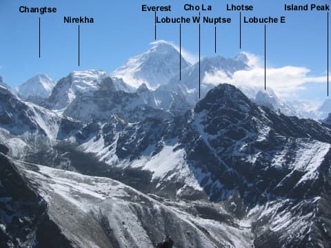
"The Cho La Twin Peak"
Nirekha Peak is situated on the crest extending north from Cho La Pass, between the Gokyo Valley and Lobuche.
It features two distinct summits (East and West) connected by an aesthetic ice ridge.
Route, acclimatisation and permit notes for Nirekha from the Nepal Side side, plus practical safety advice.
Elevation recorded at 6,159 m (20,206 ft).
Located on the boundary ridge of the Sagarmatha National Park.
Two Summits: The true summit is the North/West summit, accessible across a narrow, corniced ice ridge.
Approached from either Dragnag (Gokyo side) or Dzongla via the Cho La glacier high camp.
The standard season on Nirekha is Spring & Autumn (Mar–May / Sep–Nov). Glacier Navigation: Requires navigating crevassed glaciers; full roped glacier travel mandatory.
Approaches to Nirekha begin from Nepal Side in Solukhumbu District, where the main objective is the Kanger Pass Route. Confirm current permit, insurance, and national park requirements before departure.
Plan for road travel to the Nepal Side trailhead, then several days of walking before you reach the foot of Nirekha. Gain height gradually, take a rest day before moving to high camp, and keep a spare weather day in reserve during Spring & Autumn.
Summit day on a 6,159 m objective is long, so start early and set a clear turn-around time. If the Kanger Pass Route is crowded or the snow is unstable, waiting a day is almost always better than pushing on.
Nirekha "The Cho La Twin Peak" stands at 6,159 m in Solukhumbu District, Cho La Pass Area. The figures below summarise the mountain for trip planning.